• Categories
Collapse

The Silver Fern

Extreme Weather

Scheduled Pinned Locked Moved Off Topic
590 Posts 57 Posters 30.3k Views
Extreme Weather
    • Oldest to Newest
    • Newest to Oldest
    • Most Votes
Reply
  • Reply as topic
Log in to reply
This topic has been deleted. Only users with topic management privileges can see it.
  • taniwharugbyT Offline
    taniwharugbyT Offline
    taniwharugby
    replied to dogmeat on last edited by taniwharugby
    #253

    @dogmeat yeah it aint looking good on one of the models I have seen....will be pretty intense amount of rainfall from monday AM, no doubt accompanied by alot of wind unlike the last one.

    The time you want them to get it very wrong...

    1 Reply Last reply
    0
  • MajorRageM Offline
    MajorRageM Offline
    MajorRage
    replied to dogmeat on last edited by
    #254

    @dogmeat that’s shit. Scum are attracted to anything.

    Take it your brothers old Neighbour’s arrested?

    dogmeatD 1 Reply Last reply
    0
  • dogmeatD Offline
    dogmeatD Offline
    dogmeat
    replied to MajorRage on last edited by
    #255

    @MajorRage Sorry I didn't make it clear.

    My brother's neighbour was the old guy who had the knife at his throat. Presumably by the same gang who turned over all the other (vacant) properties.

    I have heard reports of the same thing happening in other parts of Auckland.

    taniwharugbyT 1 Reply Last reply
    0
  • taniwharugbyT Offline
    taniwharugbyT Offline
    taniwharugby
    replied to dogmeat on last edited by
    #256

    @dogmeat yep, shitbags are out in force the past year or 2....our community page is always mentioning suspicious vehicles, people coming onto properties at night, most opportunistic, but doesnt take much for it to escalate either...

    1 Reply Last reply
    0
  • StargazerS Offline
    StargazerS Offline
    Stargazer
    wrote on last edited by
    #257

    I don't like the look of Gabrielle here

    Windyty, SE

    Professional weather forecast

    Professional weather forecast

    50+ weather layers, weather radar and satellite

    boobooB 1 Reply Last reply
    0
  • boobooB Do not disturb
    boobooB Do not disturb
    booboo
    replied to Stargazer on last edited by
    #258

    @Stargazer said in Extreme Weather:

    I don't like the look of Gabrielle here

    Windyty, SE

    Professional weather forecast

    Professional weather forecast

    50+ weather layers, weather radar and satellite

    That model seems to show it very slow over NZ ... which is sub-optimal.

    taniwharugbyT 1 Reply Last reply
    0
  • taniwharugbyT Offline
    taniwharugbyT Offline
    taniwharugby
    replied to booboo on last edited by
    #259

    @booboo yea it moves pretty fast down from Aus then slows down over NZ...

    The current modelling, which I hope is wrong, does not look good at all.

    Is a bit of a worry, especially professionally...we recently had a webinar with a major insurer going through some of the claims in Auckland, some big numbers gonna come out of it and this is gonna make things worse.

    nzzpN 1 Reply Last reply
    2
  • nzzpN Online
    nzzpN Online
    nzzp
    replied to taniwharugby on last edited by
    #260

    @taniwharugby weather related insurance costs look like they're on an exponential curve. It's damn scary... Climate change is a real trend with time

    taniwharugbyT 1 Reply Last reply
    0
  • taniwharugbyT Offline
    taniwharugbyT Offline
    taniwharugby
    replied to nzzp on last edited by taniwharugby
    #261

    @nzzp yeah the Auckland event alone is looking like being NZs highest weather event, and only behind the 2 EQs for any events in NZ

    Add in the inflationary pressures already out there in construction, shortage of tradies, and then throw a fucking Cyclone into the mix...already high property insurance costs in NZ are gonna go up, more, again...

    I expect at some point, the off-shore re-insurers will limit some of the coverage they offer in NZ (similar to parts of Aus where there is no cover for some flood events)

    Makes me wonder how people get on living in the US Mid-West / Tornado alley!

    1 Reply Last reply
    0
  • mariner4lifeM Offline
    mariner4lifeM Offline
    mariner4life
    wrote on last edited by
    #262

    don't take this the wrong way but

    it's been raining here since before christmas. we've now had 2 sunny days in a row. Cheers Gab

    1 Reply Last reply
    1
  • taniwharugbyT Offline
    taniwharugbyT Offline
    taniwharugby
    wrote on last edited by
    #263

    Stunning day here today, brilliant blue sky at moment.

    Nek minut, this cyclone sounds worse by the day...some predictions the worst storm to hit us this century.

    Need this high sitting over NZ now to man up and stay put forcing Gabrielle out into the pacific!

    nzzpN 1 Reply Last reply
    0
  • nzzpN Online
    nzzpN Online
    nzzp
    replied to taniwharugby on last edited by
    #264

    @taniwharugby said in Extreme Weather:

    some predictions the worst storm to hit us this century.

    The tracking seems to be most likely to be heading east of the coutnry - but slow moving. May still be a nightmare, but it isn't a direct hit thankfully. Media going nuts - but the reality is we still don't know.

    Crossed fingers it isn't bad ... but we're preparing anyway.

    Ex-Tropical Cyclone Gabrielle Tracker | Cyclocane
    taniwharugbyT 1 Reply Last reply
    1
  • taniwharugbyT Offline
    taniwharugbyT Offline
    taniwharugby
    replied to nzzp on last edited by
    #265

    @nzzp yeah a couple of tracking models do see it being slightly further east than yesterday and wind speeds look to have dropped too when it gets to NZ.

    dogmeatD 1 Reply Last reply
    1
  • dogmeatD Offline
    dogmeatD Offline
    dogmeat
    replied to taniwharugby on last edited by
    #266

    @taniwharugby Met Service guy on radio within the last hour was very conservative about it dropping in intensity. said it might drop over the 36 hours but was also just as likely to intensify as it hits NZ.

    Does appear to be tracking more over BOP and East Cape but said winds of 90-120 knots can be expected up to 140km from epicentre and rain still in the order of a month's worth in 24 hours within that area. So effectively Northland, Auckland Coromandel BOP, Gisborne Hawkes Bay at risk.

    taniwharugbyT 1 Reply Last reply
    0
  • HigginsH Offline
    HigginsH Offline
    Higgins
    wrote on last edited by Higgins
    #267

    Our weather patterns traditionally move west to east but these tropical cyclones seem to go east to west a lot of the time, go figure that one out.

    1 Reply Last reply
    0
  • taniwharugbyT Offline
    taniwharugbyT Offline
    taniwharugby
    replied to dogmeat on last edited by
    #268

    @dogmeat yeah we just wont really know until it hits, I expect they are also talking it up so as to not come under fire if it does hit us full force.

    1 Reply Last reply
    2
  • M Offline
    M Offline
    Machpants
    replied to taniwharugby on last edited by
    #269

    @taniwharugby said in Extreme Weather:

    Brynderwyns ain't gonna be open anytime soon

    IMG-20230131-WA0000.jpg

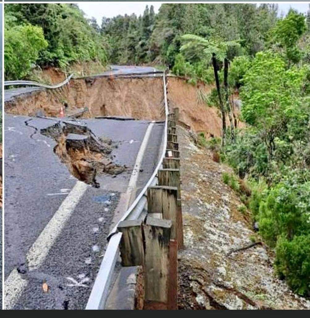
    Whilst not Brynderwins, is looking a fuck load worse today

    47b8d099-8cae-4879-9c21-d3099a4675a0-image.jpeg

    1 Reply Last reply
    3
  • nzzpN Online
    nzzpN Online
    nzzp
    wrote on last edited by
    #270

    The latest models look like Gabrielle is probably tracking right over NZ.

    Could be ugly. Ffs, not what we bloody need

    M taniwharugbyT 2 Replies Last reply
    0
  • M Offline
    M Offline
    Machpants
    replied to nzzp on last edited by
    #271

    @nzzp said in Extreme Weather:

    The latest models look like Gabrielle is probably tracking right over NZ.

    Could be ugly. Ffs, not what we bloody need

    Yup Kaitaia here I come!

    1 Reply Last reply
    0
  • taniwharugbyT Offline
    taniwharugbyT Offline
    taniwharugby
    replied to nzzp on last edited by taniwharugby
    #272

    @nzzp yeah seems to change path from cruising by the east coast to come right over us...definitely alot of worried people about...supposed to hit NOrfolk tomorrow, hopefully the expected drop to cat 2 by then happens and then keeps weakening...

    85d33b59-8e3b-4907-ba51-d455a06a00f6-image.png

    1 Reply Last reply
    0

Extreme Weather
Off Topic
  • Login

  • Don't have an account? Register

  • Login or register to search.
  • First post
    Last post
0
  • Categories
  • Login

  • Don't have an account? Register

  • Login or register to search.