• Categories
Collapse

The Silver Fern

Extreme Weather

Scheduled Pinned Locked Moved Off Topic
590 Posts 57 Posters 30.3k Views
Extreme Weather
    • Oldest to Newest
    • Newest to Oldest
    • Most Votes
Reply
  • Reply as topic
Log in to reply
This topic has been deleted. Only users with topic management privileges can see it.
  • dogmeatD Offline
    dogmeatD Offline
    dogmeat
    replied to taniwharugby on last edited by
    #266

    @taniwharugby Met Service guy on radio within the last hour was very conservative about it dropping in intensity. said it might drop over the 36 hours but was also just as likely to intensify as it hits NZ.

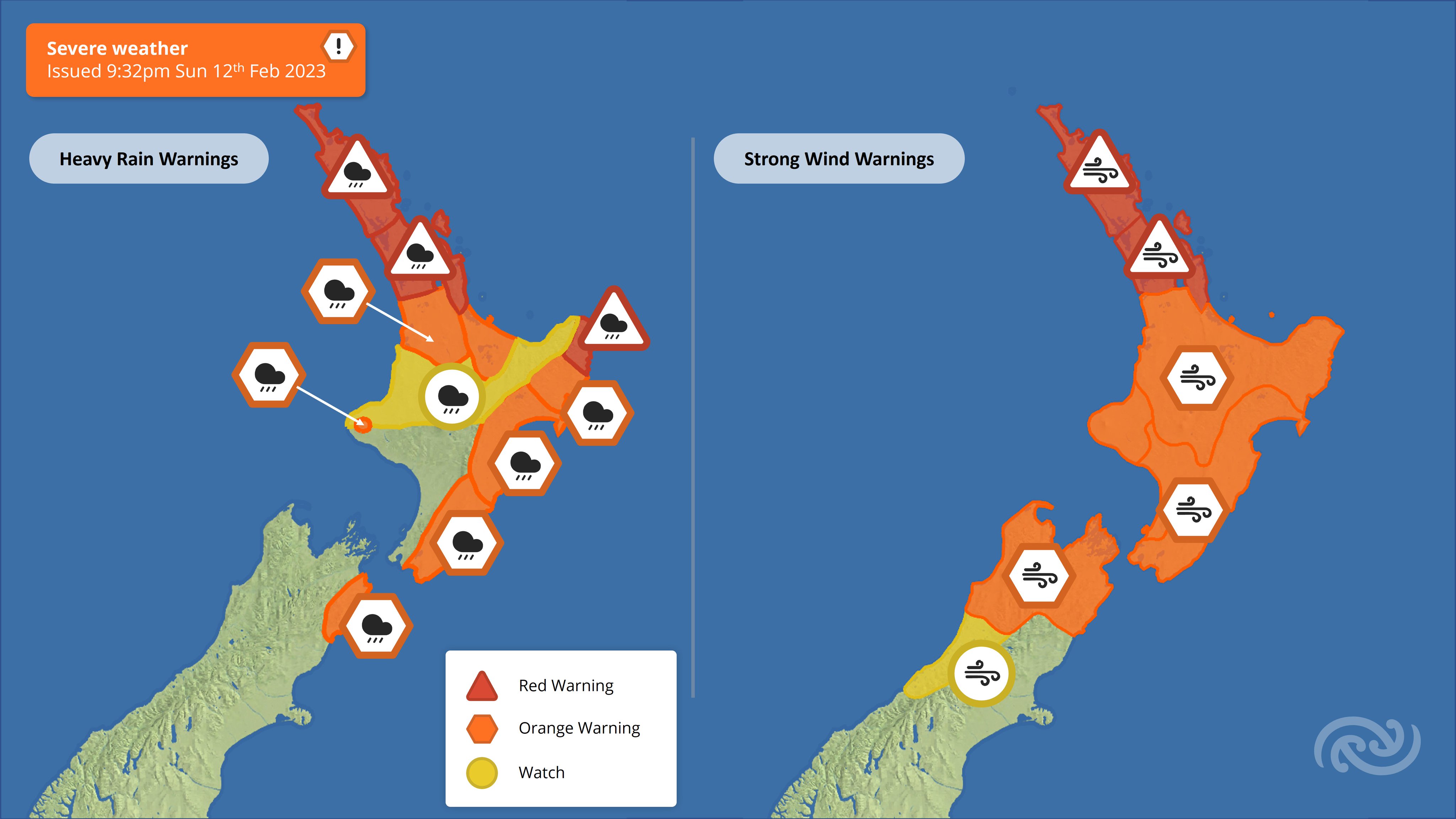
    Does appear to be tracking more over BOP and East Cape but said winds of 90-120 knots can be expected up to 140km from epicentre and rain still in the order of a month's worth in 24 hours within that area. So effectively Northland, Auckland Coromandel BOP, Gisborne Hawkes Bay at risk.

    taniwharugbyT 1 Reply Last reply
    0
  • HigginsH Offline
    HigginsH Offline
    Higgins
    wrote on last edited by Higgins
    #267

    Our weather patterns traditionally move west to east but these tropical cyclones seem to go east to west a lot of the time, go figure that one out.

    1 Reply Last reply
    0
  • taniwharugbyT Offline
    taniwharugbyT Offline
    taniwharugby
    replied to dogmeat on last edited by
    #268

    @dogmeat yeah we just wont really know until it hits, I expect they are also talking it up so as to not come under fire if it does hit us full force.

    1 Reply Last reply
    2
  • M Offline
    M Offline
    Machpants
    replied to taniwharugby on last edited by
    #269

    @taniwharugby said in Extreme Weather:

    Brynderwyns ain't gonna be open anytime soon

    IMG-20230131-WA0000.jpg

    Whilst not Brynderwins, is looking a fuck load worse today

    47b8d099-8cae-4879-9c21-d3099a4675a0-image.jpeg

    1 Reply Last reply
    3
  • nzzpN Offline
    nzzpN Offline
    nzzp
    wrote on last edited by
    #270

    The latest models look like Gabrielle is probably tracking right over NZ.

    Could be ugly. Ffs, not what we bloody need

    M taniwharugbyT 2 Replies Last reply
    0
  • M Offline
    M Offline
    Machpants
    replied to nzzp on last edited by
    #271

    @nzzp said in Extreme Weather:

    The latest models look like Gabrielle is probably tracking right over NZ.

    Could be ugly. Ffs, not what we bloody need

    Yup Kaitaia here I come!

    1 Reply Last reply
    0
  • taniwharugbyT Offline
    taniwharugbyT Offline
    taniwharugby
    replied to nzzp on last edited by taniwharugby
    #272

    @nzzp yeah seems to change path from cruising by the east coast to come right over us...definitely alot of worried people about...supposed to hit NOrfolk tomorrow, hopefully the expected drop to cat 2 by then happens and then keeps weakening...

    85d33b59-8e3b-4907-ba51-d455a06a00f6-image.png

    1 Reply Last reply
    0
  • No QuarterN Offline
    No QuarterN Offline
    No Quarter
    wrote on last edited by
    #273

    Stay safe out there everyone, let's hope this just fizzles out and is a non event

    nzzpN 1 Reply Last reply
    0
  • nzzpN Offline
    nzzpN Offline
    nzzp
    replied to No Quarter on last edited by
    #274

    @No-Quarter said in Extreme Weather:

    Stay safe out there everyone, let's hope this just fizzles out and is a non event

    That's a very low probability likelihood unfortunately. Looking like it's going to the east of us, but will still be brutal

    taniwharugbyT 1 Reply Last reply
    0
  • taniwharugbyT Offline
    taniwharugbyT Offline
    taniwharugby
    replied to nzzp on last edited by
    #275

    @nzzp one of the trackers I am watching has the worst of the rain on the west side of the cyclone too.

    Looks like it will become an extratropical cyclone tonight, which means a wider path of weather

    Neave Interactive

    Severe Tropical Cyclone Gabrielle 2023 | Zoom Earth

    Severe Tropical Cyclone Gabrielle 2023 | Zoom Earth

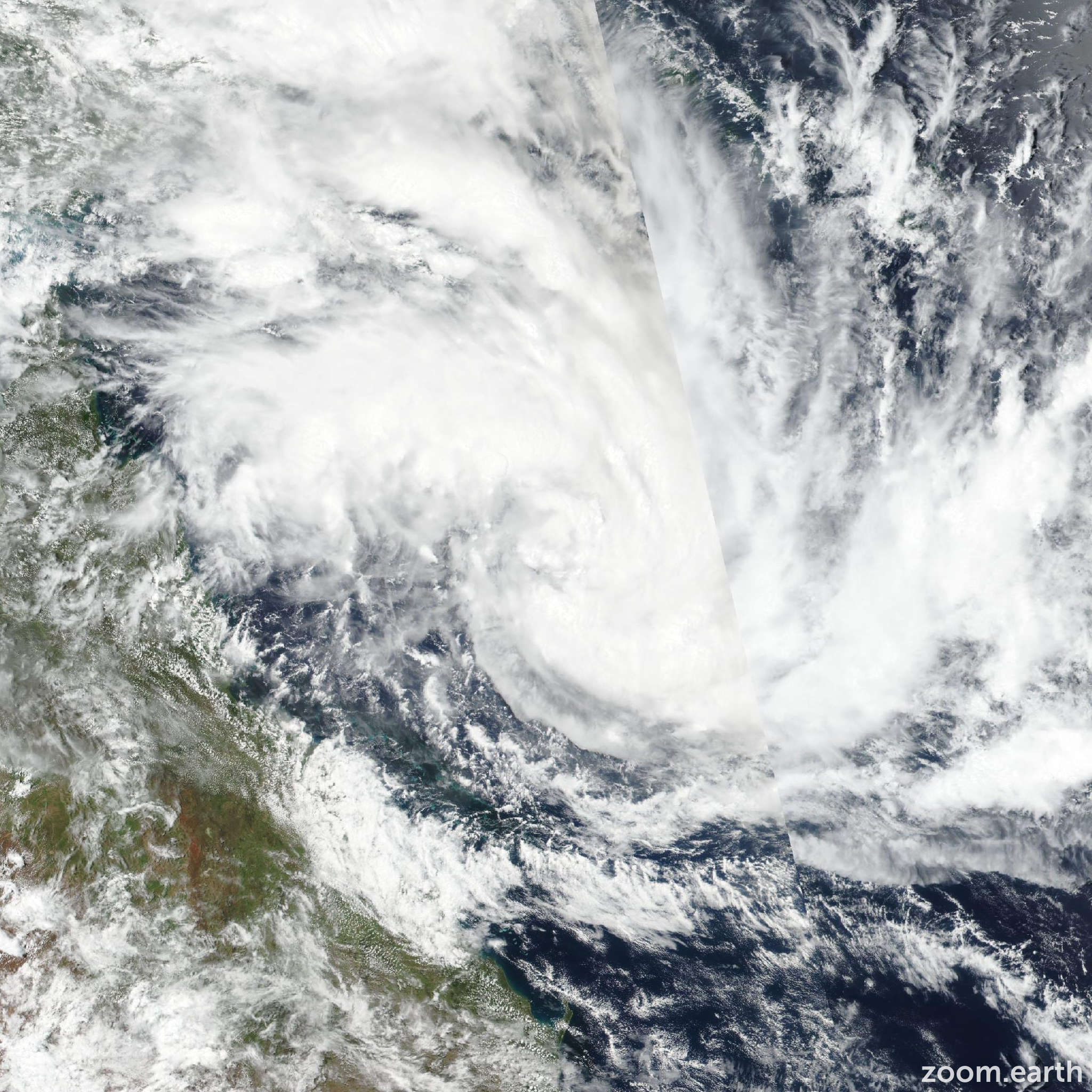
    Satellite images, weather maps and tracks of Category 3 Tropical Cyclone Gabrielle 2023, 6 - 12 February. Max wind speed 165km/h.

    a619e055-d52f-4cd4-85df-1d35cfe99598-image.png

    1 Reply Last reply
    1
  • taniwharugbyT Offline
    taniwharugbyT Offline
    taniwharugby
    wrote on last edited by taniwharugby
    #276

    looks like Gabrielle likes the look of NZ and is looking to touch down....shes pretty wild here at moment.

    Anyone follow Matt Watson on IG, he's got a house right on the coast just north of the BOI entrance I think it is, he is posting some clips and looks pretty wild there too

    1 Reply Last reply
    0
  • mariner4lifeM Offline
    mariner4lifeM Offline
    mariner4life
    wrote on last edited by
    #277

    Weird how NZ seems to get more cyclones than us these days

    1 Reply Last reply
    1
  • nzzpN Offline
    nzzpN Offline
    nzzp
    wrote on last edited by
    #278

    Schools are starting to cancel attendance tomorrow. Good call.

    Superb Owl at home this year - not risking public transport in the teeth of a storm unfortunately. Going to be smoking up some moink balls - beef meatballs wrapped in bacon (moo + oink). My smoking area is pretty sheltered thankfully...

    1 Reply Last reply
    1
  • taniwharugbyT Offline
    taniwharugbyT Offline
    taniwharugby
    wrote on last edited by taniwharugby
    #279

    Is quite odd, sky is fairly bright all things considered.

    Wind and rain picked up in last hour or 2, we have had no power for 2 hours now, 65mm in last 24 hours, 30mm in last 5 hours.

    she is a huge system

    f0e28b92-3f1d-44f2-86e8-5e364e58513f-image.png

    M 1 Reply Last reply
    2
  • CrucialC Offline
    CrucialC Offline
    Crucial
    wrote on last edited by
    #280

    This YouTube channel is a good place for detailed discussion and forecasting

    boobooB 1 Reply Last reply
    1
  • M Offline
    M Offline
    Machpants
    replied to taniwharugby on last edited by
    #281

    @taniwharugby said in Extreme Weather:

    Is quite odd, sky is fairly bright all things considered.

    Wind and rain picked up in last hour or 2, we have had no power for 2 hours now, 65mm in last 24 hours, 30mm in last 5 hours.

    she is a huge system

    f0e28b92-3f1d-44f2-86e8-5e364e58513f-image.png

    We've deployed up North and it is nowhere near as bad here as forecast, thankfully. Looks like it is worse back down south, power out at my place too.

    taniwharugbyT 1 Reply Last reply
    3
  • taniwharugbyT Offline
    taniwharugbyT Offline
    taniwharugby
    replied to Machpants on last edited by taniwharugby
    #282

    @Machpants our power came back on, fully expect it to go off again though

    We are having big gusts, the odd heavy downpour and then almost calm for a period...I have a maple I planted which is about 6m and it bends pretty well, the neighbours totara that are probably 15-20 barely seem to move at all with the wind.

    It aint looking too flash the next 24+ hours, hope she calms down and doesnt cause too much more carnage

    1 Reply Last reply
    1
  • ChrisC Offline
    ChrisC Offline
    Chris
    wrote on last edited by Chris
    #283

    I hope Everyone stays safe and gets through this cyclone. I have some family in whangaparaoa

    I hope it’s not as bad as they say for everyone’s sake.

    1 Reply Last reply
    3
  • taniwharugbyT Offline
    taniwharugbyT Offline
    taniwharugby
    wrote on last edited by taniwharugby
    #284

    Power back off...northpower advise likely off all night and possibly days.

    Far North power outages are similar I believe

    Screenshot_20230212-204037_Chrome.jpg

    1 Reply Last reply
    0
  • StargazerS Offline
    StargazerS Offline
    Stargazer
    wrote on last edited by
    #285

    Bigger image:

    alt text

    1 Reply Last reply
    0

Extreme Weather
Off Topic
  • Login

  • Don't have an account? Register

  • Login or register to search.
  • First post
    Last post
0
  • Categories
  • Login

  • Don't have an account? Register

  • Login or register to search.